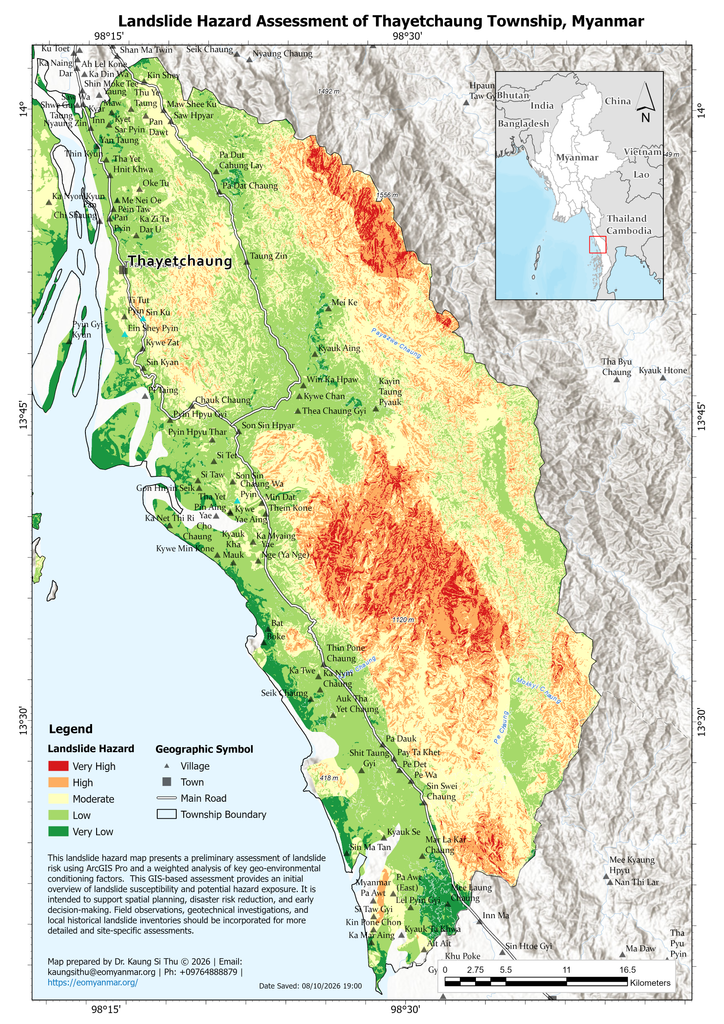
This map illustrates the spatial distribution of landslide hazard across Thayetchaung township, Tanintharyi Region, Myanmar, highlighting areas with different levels of landslide susceptibility. The results provide useful information to support disaster preparedness, land-use planning, disaster risk reduction, and sustainable infrastructure development. The study area is characterized by coastal plains that transition into the rugged, steep terrain of the Tenasserim hills. During the intense monsoon season, this topographic configuration, combined with highly weathered granitic bedrock and structural fault lines, significantly increases the potential for slope instability, shallow landslides, and debris flows, particularly in mountainous and structurally weakened zones.
The landslide hazard assessment was conducted using ArcGIS Pro and a weighted analysis of key geo-environmental conditioning factors. Due to the region’s rugged setting and heavy monsoon climate, landslide hazard should be given particular attention, especially during periods of intense or prolonged rainfall. Areas classified as High and Very High Hazard Zones require greater consideration for slope stabilization, safe infrastructure routing, land-use planning, and community disaster preparedness.
Disclaimer: This GIS-based assessment provides a preliminary overview of landslide hazard and potential exposure. The results are intended to support spatial planning, disaster risk reduction, and early decision-making and should not be considered a substitute for detailed field-based geotechnical risk assessments. Local rainfall thresholds, field observations, historical landslide records, and site-specific geological investigations should be incorporated for more detailed and localized analysis.
Download High Resolution A3 Size: [https://drive.google.com/file/d/1hOjXtDMYqTEVFDnuWKOGXk78QDe6H83-/view?usp=sharing]